Skip to content

Hiking With Cloud Whisperer

“You’re off to great places, today is your day. Your mountain is waiting, so get on your way.” ~Dr. Seuss

  • Home
  • All About Me
  • Hiking Adventures
    • 2020 Pinhoti Trail Section Hike
      • Pinhoti Section Hike Planning
      • Pinhoti Trail Gear
  • Bikepacking Adventures
    • 2022 Longleaf Trace
      • Longleaf Trace Gear
    • 2022 Natchez Trace Section
  • Contact
  • Instagram
  • YouTube

Tag: maps

2022 Longleaf Trace

Posted on December 16, 2021January 2, 2022 by Cloud Whisperer

Kicking off my bikepacking adventure with the Longleaf Trace- located in Southern Mississippi. I wanted to start out with this one since: it is the closest trail to my home, it’s fully paved, had established campgrounds on the route (to include one that can only be reached via bike), and has several amenities to assist.

I didn’t want to get too ahead of myself getting into something new, so I liked the idea of testing this out where I was close to home and could be bailed out if needed and to fully learn how my bike will perform and my athletic ability by starting on a paved road.

Longleaf Trace

The Longleaf Trace was completed as a Rails-to-Trails conservancy project in 2000, erected along a portion of the abandoned line of the Mississippi Central Railroad. Beginning at the gateway in Hattiesburg near The University of Southern Mississippi, the Longleaf Trace traverses through five communities for 44 miles. Source: https://www.longleaftrace.org/history-of-the-trace

Map of the Longleaf Trace
More Details

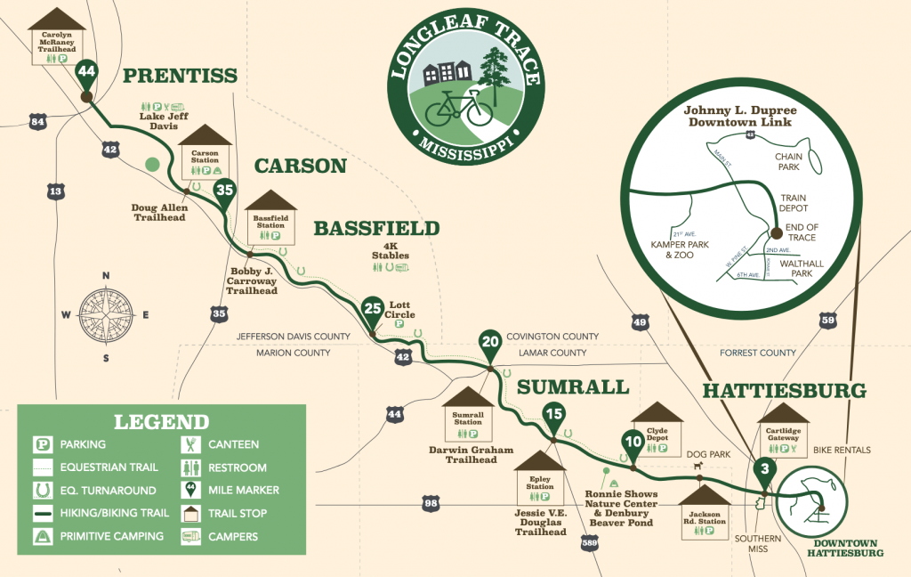
Our intention is to complete the 44 miles over the span of two days. Starting at the southern end in Hattiesburg, camping near the Carson Station, and finishing out the next day at the northern end at the Carolyn McRaney Trailhead. We will be staging a vehicle at either end.

Stay tuned to how we will get our bikes set up to carry our camping gear!

Posted in UncategorizedTagged bikepacking, longleaf trace, maps, mississippi, planningLeave a Comment on 2022 Longleaf Trace

Pinhoti Section Hike Planning

Posted on July 27, 2020July 29, 2020 by Cloud Whisperer

This was my first endeavor of planning a section hike from “scratch”. What I mean by that is I didn’t use a pre-planned route like I have in past (Example: SNP Backcountry Trips). We decided that we wanted to do a section hike instead of a out and back hike or circuit hike. That way we were getting to do more of the trail without backtracking over the same area. However, with starting and ending at different points brings up different logistical planing.

Below are several resources that I used to plan and read up about this trail:

  • Pinhoti Trail Alliance (This was a huge resource for me to show the different sections. However, it has been designed in such a format that it is difficult to read)
  • Pinhoti 2014 Trail Map/Waypoints
  • Guthook Guides (This app has been downloaded to my phone and will be my main source of mapping on the trail)
  • Darwin OntheTrail 2018 Pinhoti Trail Thru-hike
    • Thru-Hike YouTube Videos
  • Whitewater’s Pinhoti 2016 Thru-hike Journal
  • Greenbelly Planning Your Thru-hike 101- Pinhoti
  • Alabama Hiking Trail Society- Pinhoti Trail
  • Pinhoti Trail Alliance Facebook Group

Once I had an overall sense of the trail, read and watched as much as I could, I decided that going for an average of 10 miles a day for the 5 days that I had would be a good feasible goal. Being this my first time in attempting a multi day trip, the heat, and how much shape I know I’m in, I didn’t want to over shoot the mileage.

Next, step came “Which 50-60 miles should I do?” and that answer came through asking some questions on the Facebook page and reading through multi people’s trail journals to see what their highlights of the trail were. Nearly every thing I saw lead me to the Cheaha State Park area, which are in sections 6 & 7, so throwing section 5 on the front end and section 8 on the back end gave me a total of 53.9 miles.

Pinhoti Section Hike Map
Pinhoti Sections 5-8
Daily Plan

Posted in PlanningTagged hiking, maps, planningLeave a Comment on Pinhoti Section Hike Planning

Recent Posts

  • 2022 Natchez Trace Section February 8, 2022
  • Longleaf Trace Gear January 11, 2022
  • 2022 Longleaf Trace December 16, 2021
  • Pinhoti Trail Gear July 28, 2020
  • Pinhoti Section Hike Planning July 27, 2020

Recent Comments

    • Home
    • All About Me
    • Hiking Adventures
      • 2020 Pinhoti Trail Section Hike
        • Pinhoti Section Hike Planning
        • Pinhoti Trail Gear
    • Bikepacking Adventures
      • 2022 Longleaf Trace
        • Longleaf Trace Gear
      • 2022 Natchez Trace Section
    • Contact
    • Instagram
    • YouTube
    Back to top
    Proudly powered by WordPress | Theme: sylvan by Saunders Technology.